
Population Changes in Kazakhstan
In this project, I examined demographic changes in Kazakhstan over the past three decades of independence. The project was carried out using the R programming language and libraries such as tidyverse, giscoR, terra, and tidyterra.
Methods and Tools
The following tools and libraries were used for creating this visualization:
- tidyverse: A collection of packages for data manipulation and visualization.
- giscoR: A package for working with geographic data.
- terra: A library for spatial data analysis.
- tidyterra: A package that combines the capabilities of tidyverse and terra.
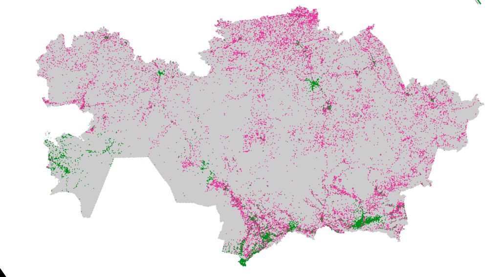
Visualization Description
The map graphically represents the population changes in Kazakhstan. The color scheme of the map is as follows:
- Pink 💗: Decrease in population.
- Green 💚: Increase in population.
- Gray: Uninhabited territories.
Conclusions
Analyzing the map allows us to draw several key conclusions:
1. Urbanization: There is an active process of urbanization. People are moving to large cities and the capital, Astana. According to the World Bank, urban population in Kazakhstan increased from 54% in 1991 to 57% in 2020.
2. Sparsely populated areas : Most of Kazakhstan remains sparsely populated. Approximately 43% of the population lives in rural areas, with large parts of the country, especially in the central regions, remaining uninhabited.
3. Population growth in Mangystau region: This region is actively being populated. Mangystau has seen a significant increase in population due to the development of the oil and gas industry. According to the Statistics Committee of Kazakhstan, the population in Mangystau region grew by over 30% from 2009 to 2020.
4. Migration to the south due to drought: Due to frequent droughts in the south of the country, people are moving even further south. Regions like Almaty and South Kazakhstan have seen increased migration as people seek more stable living conditions.
5. Population outflow in the north: There is a significant outflow of population in the north of the country. The northern regions, historically home to many ethnic Russians, have experienced population declines due to emigration to Russia and other factors. For instance, the population of the North Kazakhstan region decreased by about 12% from 2009 to 2020.
6. Different population densities: The map clearly shows differences in population density across regions. The population density in cities like Almaty and Astana is significantly higher compared to rural areas.
Resolution
This work vividly demonstrates how demographic processes and natural conditions affect the population of Kazakhstan. Data visualization helps to better understand these processes and can serve as a basis for further research and decision-making at the state level.
Code
The entire project code is available on GitHub